

Team studying sea ice near Pond Inlet before shipping starts
Two time-lapse cameras will capture floe edge in Eclipse Sound
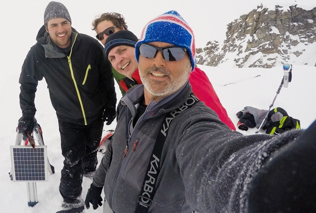
After climbing 500 metres above Eclipse Sound, the Ocean’s North team prepares to install the first camera. (PHOTO BY TREVOR TAYLOR)
If Baffinland Iron Mines Corp. ever gets permission to break ice in spring to ship ore from its Milne Inlet port, the impact of that shipping on the floe edge in Eclipse Sound will all be caught on camera.
Researchers from the Université du Québec à Rimouski and The Pew Charitable Trusts are using time-lapse imagery to document changes in the floe edge at Eclipse Sound to see how the ice behaves in advance of Baffinland changing the ice’s natural behaviour.
“Really it’s to start to give us a better picture of the resilience of that floe edge and its vulnerability to intensive icebreaking,” said Chris Debicki, Nunavut project director for Oceans North Canada, a Pew Charitable Trust.
Debicki and oceanographer Dany Dumont from Université du Québec à Rimouski, teamed up in an attempt to answer some questions about Baffinland’s shipping route in Eclipse Sound.
Can hunters travel on the ice safely? Does it harm the ecosystem? Will all sea ice in Eclipse Sound remain stable after intensive icebreaking?

“We started looking around and we couldn’t find any good answers,” Debicki said.
Eclipse Sound, which separates Baffin and Bylot islands where Pond Inlet is located, falls inside the yet-to-be-created Lancaster Sound National Marine Conservation Area.
Baffinland currently has permission to ship up to 4.2 million tonnes of iron ore out of Milne Inlet, only during the ice-free season.
But the owner of the Mary River mine in North Baffin would like to expand its shipping to a maximum of 12 million tonnes of ore over 10 months of the year, with the help of icebreakers.
The Nunavut Planning Commission said ice breaking in winter contravened an existing land use plan because it would impact hunting and travelling in the area.
But Aboriginal Affairs and Northern Development Minister Bernard Valcourt exempted Baffinland from the NPC’s decision on July 13.
Baffinland’s beefed up shipping proposal now has to go through the Nunavut Impact Review Board’s vetting process instead.
Debicki said while Baffinland studied the affects of shipping in Steensby Inlet — where the company once planned to ship ore from — he’s unsure if Eclipse Sound was studied to the same extent.
So he put together a team of scientists who specialize in capturing differences in ice changes using time-lapse cameras.
The cameras will record subtle changes in sea ice and monitor the effects of shipping on the break-up of the ice edge.
“These cameras are literally taking tens of thousands photos of sea ice in Eclipse Sound with a particular focus on where the floe edge is normally located in the spring months,” Debicki said.
The team set up two cameras in mid-May on steep cliffs at about 600 metres elevation and trained their lenses on Eclipse Sound to record how the sea ice evolves throughout the spring and summer.

This year it’s a kind of baseline study. There’s no icebreakers going through the sound yet but they expect to capture transport vessels cruising through the area on their cameras.
Debicki and his team are hopeful they can make this a multi-year project, which would compare the before and after effects of icebreakers, if they’re eventually allowed to operate out of Milne Inlet.
But the team almost didn’t make it up those steep cliffs in the first place. In Debicki’s blog, he describes a dangerous turn in the weather which held up the project.
Debicki wrote fog “swallowed everything — shacks, mountains, eskers, beach, icebergs.” The sea ice was indistinguishable from the sky.
Despite the danger, the group pushed on.
“So we decided to slug it out, just really travelling on GPS and chutzpah I guess,” Debicki said.
The team mounted the cameras with steel cables and expect to retrieve them at the end of August.
The researchers also plan on sharing the images with Pond Inlet residents afterwards.
The hope is that the images can inform Nunavummiut about potential risks of the shipping process, “with the view to recommending shipping strategies to reduce the impact on both the ecology and the human use of the sea ice,” said Debicki.
“The Lancaster Sound’s floe edge is some of the most productive in the Arctic.”
In fact, it’s home to more than a million birds, Canada’s largest polar bear subpopulations and an estimated 75 per cent of the world’s narwhals.
“And we also know Pond Inlet has a very, very important connection culturally, historically, and nutritionally to that floe edge,” Debicki said.
“It would be a great tragedy if that connection was severed,” he said.
Debicki stressed he’s not against the Mary River mine — he just wants responsible shipping that won’t unduly impact human activity or the environment.
“We’re hoping it’s going to inform good, responsible management decisions with respect to shipping and also the marine conservation area that’s planned for the area,” Debicki said.
To read more about the project and Debicki’s experience mounting the cameras, click here.

This Oceans North map shows the general location of the floe edge in Eclipse Sound in recent years, at right. The green squares show where the time-lapse cameras have been installed. (MAP COURTESY OCEANS NORTH)
(0) Comments