

GN initiative to use drones for drainage, infrastructure planning
The aerial drone mapping project has received $1.1 million for the 2023 fiscal year

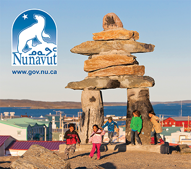
Here is a sample of aerial drone imagery from the aerial drone mapping project in Gjoa Haven. Petersen Bay is on the left side of image, and the community’s new hamlet office is near the lower right. (Image courtesy of the Government of Nunavut/ArcticUAV)

Thawing permafrost across the North can wreak havoc on communities but the GN hopes a new aerial mapping project might help avoid the problem.
Engineers and land planners are using drones to collect data that will help them plan building projects in places with good water drainage.
“Thawing permafrost [creates] problems for buildings on top of it,” said William Patch, director for planning and lands with the Department of Community and Government Services, the department responsible for the mapping project.
“We want the water to move, maintain its energy so it doesn’t stop and seep into the ground, and keep going until it all goes out into local water source.”

Nunavut’s community and government services minister David Joanasie said the aerial drone mapping project will help make “informed decisions about the placement of buildings and infrastructure, manage flood risks, and protect their permafrost soils” in the spring sitting of the legislative assembly on May 25. (File photo)
The drones will collect high-resolution images of the land surrounding communities and those images will be used to create three-dimensional digital elevation models of the land surface.
The 3D models will help experts determine how runoff from thawing permafrost impacts buildings and roads and how it may affect new construction in the communities.

In the past, Patch said engineers went into communities and looked at drainage infrastructure such as ditches and culverts to check their conditions.
They also often used satellite imagery to collect information about community drainage systems. However, these would provide data from specific locations within a community rather than an overall image.
Using drones can be up to three or four times more expensive than using satellites, the images they collect are more detailed and of higher resolution.
“A lot of community drainage is very shallow and hard to see unless you are looking specifically for them,” he said.
“Satellite imagery never picks them up.”
Patch said the GN has so far worked with the community of Gjoa Haven on the project. The cost was over $150,000 and included aerial drone imagery, creating a master drainage plan and a geotechnical plan with construction recommendations. That total will differ for each community because CGS works with different consultants, planners and engineers in every location.

Organizers hope to map other communities this summer. The Department of Community and Government Services has received $1.1 million in total for this fiscal year — $500,000 from Crown-Indigenous Relations and Northern Affairs Canada and $600,000 from Natural Resources Canada — in order to do so.
The funding is a one-time grant, Patch noted, and future drone mapping will require more funding, which his department is looking into. Patch said the department has not worked out a total cost to map every community.
CGS Minister David Joanasie, who announced the project in the legislative assembly on May 25, said, “by creating detailed maps of town sites, floodplains, and drainage systems, communities will be able to make informed decisions about the placement of buildings and infrastructure, manage flood risks, and protect their permafrost soils.”
For Patch, the aerial drone mapping project is “really about making our communities resilient in the face of climate change.”
“What happens is that all our models will be used for a variety of other climate change studies, including drainage planning, geotechnical and floodplain mapping,” he said.
“So that we can be confident that the community will be able to thrive.”
This is a perfect example of glitzy tech couched in climate change rationalization over common sense and practicality.
To my knowledge, Nunavut Arctic College nor MTO has ever offered a surveying program, and to my knowledge, we have never had an Inuk Canada Land Surveyor working in Nunavut. Even though there is plenty of business to be had, we have no Inuit Owned Surveying Firm, although some IOF may offer surveying services through southern joint ventures.
Given how much land we have up here, this is basic stuff that Nunavut needs and should have. This really helps to tell simple things like if a culvert is placed too high or too low.
That means the local capacity to use way, way cheaper but effective things like theodolites, levels and transits almost does not exist past the summer student hired to hold a staff for a southerner the odd time formal survey work is ever done up here. This gear has been around for hundreds of years, and it works.
This means communities will never get to the point where they are managing things themselves with local equipment and people, and will have to wait for a drone to be assigned to them, and for others elsewhere to take and interpret that information to tell them how to build and manage their own infrastructure.
Saying we have ponding and slumping in the communities due to climate change is an excuse to get money. We have ponding and slumping in the communities mainly because local people who have abundant skills to build roads and pads often do not know how to read and follow engineered drawings, and there is rarely anybody around to check if things were built to spec.
A much stronger case could be made to use that $1.1M to teach surveying to Inuit in Nunavut. But that would mean the government will have to switch gears and put people and skills development first instead of the latest technological fad and issue.
A quick Google search of the company shown in the picture would tell you that ArcticUAV is inuit owned and operated. Delve slightly deeper and you will see their chairperson, an inuk, studied at an Ivy League university to get where he is. The idea that putting countless dollars into training will actually achieve something has been proven false over and over again.
To do a proper survey using the traditional method, which you were talking about, would take weeks for Gjoa Haven alone. The actual fieldwork with a drone with a higher resolution output could be measured in days, perhaps hours.
In other words, you’re advocating Inuit be trained in methods which are becoming obsolescent for this type of survey.
Dont go flying over my house
Just use google earth, it’s free.
Look into who owns the drones.