


Flight 6560 crashed shortly after last communication with Resolute Bay airport: eyewitness
“I saw First Air ground crew waiting for the aircraft and wondering where it was”
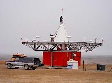
The Aug. 20 crash site First Air flight 6560 is close to the VOR (VHF Omni-directional Radio Ranges) beacon for Resolute Bay airport — called the “Sombrero” by locals due to its resemblance to that wide-brimmed hat. (PHOTO BY JANE GEORGE)
Flight International, which bills itself as the world’s leading aerospace weekly, has reported new information about the minutes leading up to and immediately after the Aug. 20 crash of First Air flight 6560 near the Resolute Bay airport.
A source from someone who worked in support of the Operation Nanook military exercise, which was occurring in Resolute Bay at the time of the crash, told Flight International he had been looking east from the airport apron when flight 6560 was due to arrive.
“I could not see the base of the hill opposite because the fog was too low,” he said.
The First Air 737-200C had said it was on final instrument landing system approach to 35T [section of the runway], but when the tower controller requested a position update a few minutes later, there was no response, and a Beech 99 pilot — on approach to 17T [another section of the runway] — was asked to try to contact the flight, with no result, Flight International said.
“I saw First Air ground crew waiting for the aircraft and wondering where it was,” said the source, who added that “an engineer thought he heard a spooling of jet engines, then a thump,” according to Flight International.
No communication was heard during a check on the VHF distress frequency 121.5MHz, the source said.

Meanwhile, the Beech 99 executed a missed approach and continued south, before turning to follow the track to 35T on which the 737 had been inbound, he told Flight International.
After it landed, followed shortly by a De Havilland DHC-6, the fog lifted and revealed smoke, flames and wreckage on the hill opposite the airport, said Flight International.
A special weather advisory, issued as soon as the wreckage was located, indicated fog and a cloud base of 300 feet (91 metres), with winds from the south.
The crash site is close to the VOR (VHF Omni-directional Radio Ranges) beacon for Resolute Bay airport — called the “Sombrero” by locals due to its resemblance to that wide-brimmed hat.
The beacon is located about 1.5 km east of the Resolute Bay runway’s centreline, said Flight International
Investigators with the Transportation Safety Board continue to comb the crash site to gather as much information as possible about wreckage and about the site.
(0) Comments