Winter temperatures are looking up, forecasts show
Some parts of territory may see higher than normal precipitation but overall Nunavut and Nunavik can look forward to mild winter
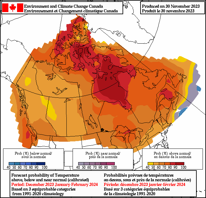
Environment and Climate Change Canada forecasts a milder than usual winter for all of Canada. (Image courtesy Environment and Climate Change Canada)
El Nino’s four-year global warming trend has meteorologists predicting a milder than normal winter for all of northern Canada.
In fact, “all of the country is forecast to be above average for the winter,” said Terri Lang, a meteorologist for Environment and Climate Change Canada, in an interview Tuesday.
That winter weather outlook may come as a surprise for the people of Kivalliq and Qikiqtaaluk regions, who were battered by blizzards over the past two weeks.
Severe winds in Arviat led to days-long power outages late last month while Pangnirtung was blasted by a similar storm last week that also brought down its power grid for several days.
“Warmer air can hold more moisture. So the more moisture you can get, the more snow you can get,” Lang said.
“The winds are created because there’s a difference between the really cold air and the really warm air. So that temperature difference creates quite strong winds.”

The Kivalliq region of Nunavut has already been battered by storms this season and can expect higher than usual levels of precipitation in the coming months, according to Environment and Climate Change Canada. (Image courtesy Environment and Climate Change Canada)
Lang acknowledged “we’ve certainly seen some stormy weather through many parts of the Arctic so far this winter. Some really humdinger storms, especially through the Kivalliq [region] right through to Arviat and places like that.
“Places that really got smacked.”
El Nino is a band of above-average sea-surface temperatures that can develop on parts of the Pacific Ocean, affecting the climate in other regions.
Lang said the federal Environment Department is forecasting higher than normal precipitation “over the high Arctic” in the Kivalliq region and over northern Quebec.
The uncommon warmth has already had an impact, particularly in the eastern Arctic.
“We are seeing really strong temperature anomalies … not just records being set, they are being shattered,” Lang said.
Information provided by the Weather Network largely corroborates Environment and Climate Change Canada’s forecast.
A “mild start to the season” will delay onset of the long spells of cold weather most Canadians are used to, the Weather Network reported last week.
Its maps show nearly all of the country experiencing above normal temperatures this winter, with sections from Eastern Ontario to the Maritimes dipping down to near normal temperatures for the period.


The head line “Some parts of territory may see higher than normal precipitation but overall Nunavut and Nunavik can look forward to mild winter” make it look like we want a mild winter… NOPE
we need it to get cold so the ice frezzes so traveling will be easier/possible later in the spring. the only people that might be happy about this are those that only travel between home and work and home and south via plane.
Mother nature don’t care what you want.
Your correct in that, however the writer of a northern newspaper could either write from a northern perspective or just not use words like “can look forward to”, which implies this mild winter is a good thing for us.
Going to Mexico for 2 week starting Dec 30th, I hope it hot, but the beer cold.