

“Blocking pattern” brings busy blizzard season to Nunavut
Weather system will continue well into February, Environment Canada says
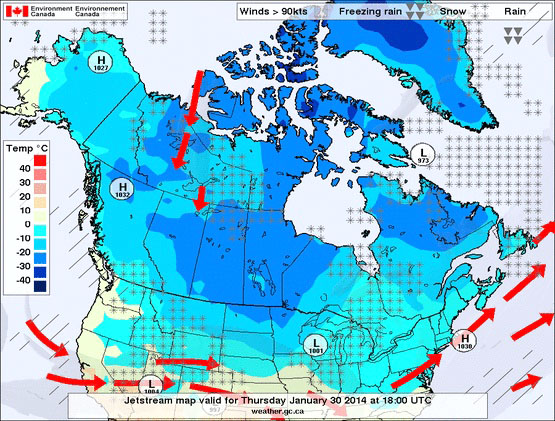
This weather chart from Environment Canada, posted Jan. 29, shows large areas of low pressure centred over Ontario and Quebec, known as the “Arctic vortex.” The system has created a “blocking pattern” that caused more blizzards than usual this month in Nunavut, according to meteorologist Brian Proctor of Environment Canada. (IMAGE FROM ENVIRONMENT CANADA)
Blizzards and windstorms are kicking up more often than normal in Nunavut at the start of 2014, thanks to a huge low-pressure system over the middle of Canada.
“It’s a pattern that happens from time to time, but it’s not typical,” said Brian Proctor, Environment Canada’s warning preparedness meteorologist.
An explosive start to the storm season Jan. 9 in the south Baffin region, where Iqaluit was hit by winds in excess of 140 kilometres per hour, was just the beginning.
The territorial capital and surrounding regions were hit by a second blizzard Jan. 27, with warnings of another on Jan. 28. The entire Kivalliq region experienced the same Jan. 24.
On the morning of Jan. 29, blizzards picked up again in communities at the northern tip of Quebec along Hudson Straight, and in Clyde River on the east coast of Baffin Island.
“Normally we see one or two of these in January,” Proctor said Jan. 29. “This year we’ve seen significantly more.”

The Edmonton-based meteorologist said a low-pressure system, centred on Ontario and Quebec and stretching up to central and eastern Nunavut, has created a “blocking pattern” in the upper atmosphere since the middle of the month.
“It’s really strong upper air pattern that’s not moving,” he said. These upper low pressure areas are what meteorologists call the “Arctic vortex,” Proctor said, which “we typically see over the Eastern Arctic this time of year.”
The difference now, he said, is that the Arctic high pressure area is further south and “more intense” than normal.
“That means there is more potential for these storms to develop.”
Higher intensity storms pick up because of “the contrast between cold air that’s in the vortex” and warm air streaming around and on top of it, he said.
Warm air streaming from the west and northwest of the country over British Columbia and Yukon, clashes with the cold.

“The more contrast there is in the temperatures between cold and warm, the more potential energy there is for storms to develop,” he said. “And because there’s more energy, those storms are more intense when they do develop.”
Unfortunately for Nunavut, the weather system doesn’t look likely to change until well into February.
“I’m not looking for any major change from now into next week,” Proctor said Jan. 29.
“It looks like we’re locked into this pattern. So no major change or major end in site yet.”
Until the system breaks, Nunavut, and the Baffin region in particular with much of Nunavik, can continue to be “problematic from time to time,” he said.
(0) Comments